Followers

Showing posts with label Prototype. Show all posts

LDE: Van Wyck

Posted by Jamie in Lilburn, Georgia, USA Tuesday, September 22, 2009 3 comments

Figure 1 Catawba River Bridge - ca. 1989
John D. Jones
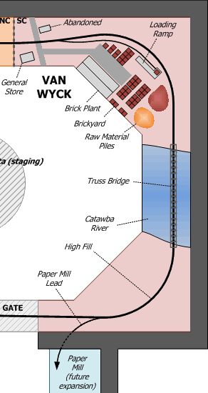
Van Wyck is an unincorporated community just on the South Carolina side of the border with North Carolina. Like most other communities in this area, the town got its start when the Seaboard Air Line came through in the 1880s. However, unlike Catawba to the south and Waxhaw to the north, Van Wyck did not get its name from the Indian territory that the railroad passed through. Originally called Little Waxhaw, the name was changed to Van Wyck by an agent of the railroad (the family name of the agent's wife was Van Wyck) to avoid confusion with the "other" Waxhaw to the north. In its early years, Van Wyck was the home to a depot (which is long gone) and a brick plant (which is still going strong today.) The original Ashe Brick Company of 1906 is today part of the Boral Bricks brand and still receives rail service from CSX. The most prominent railroad feature in the area has to be the four-span truss bridge over the Catawba River (Figure 1). This bridge will be the signature scene of the entire lower level of the layout.

» Track Plan


» Catawba River Bridge

Figure 2 Catawba River Bridge - August 2009
James Guffey/Zenfolio.com
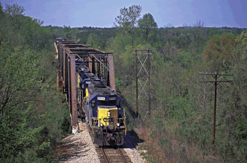
The Catawba River flows 220 miles from the Appalachians in North Carolina into the Wateree River in central South Carolina. It has been the lifeblood for agricultural and commercial development in the region for centuries. The SAL bridged the Catawba by constructing a four-span truss bridge set upon cut stone piers. S.C. state highway 5 crosses the river on an adjacent bridge, but I will only model the railroad crossing to avoid cluttering the scene. Even with the nearby highway bridge, the lack of sidewalks makes profile photos of the railroad bridge quite difficult to come by. However, views from the north can be captured from the highway overpass (Figure 2). A few notable details can be observed from the two bridge photos. The cut stone piers can be seen supporting the individual deck spans, as can the abutment that supports the north end of the bridge. The telephone poles, though not in service, have a distinctive look and will add character to the scene. Also, notice how the long trains disappear into the curve in the background; this same track geometry will be present on the model. Finally, notice the difference in the overall color of the bridge spans. In the 1980s photo, the bridge appears to be a nice shade of dark gray; most likely following a recent paint job. In the 2009 photo, however, the bridge is almost completely covered by rust, with just traces of the gray color showing through here and there. This will allow flexibility when choosing an actual color for the model.

» Paper Mill

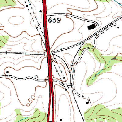
Figure 3 Paper Mill near Catawba, SC - July 1968
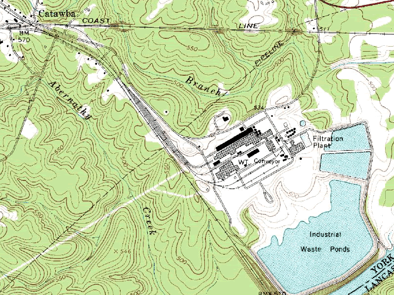
There is a massive paper mill between the town of Catawba and the Catawba River. Today, this mill is operated by Abitibi-Bowater, although this multinational corporation was obviously not the owner in the Seaboard era. A bit of additional research will be required to identify the lineage of this mill. The paper mill at Catawba is a traditional sprawling complex that is commonplace among the paper industry in the southeastern United States. There is a large pulp yard (pulp wood is received via truck in 2009), chippers, a digester, production building and various warehouses. As expected, spur tracks seem to go everywhere. Rail service is provided by both CSX and Norfolk Southern (SAL and SOU in 1966), and there is a large yard adjacent to the plant as can be seen on a topo map from 1968 (Figure 3). This paper mill is the type of industry that could be modeled as a standalone switching layout. I have reserved a 10' long wall in an adjacent room for the mill to be modeled as a future expansion. For now, the lead track will terminate at the backdrop and will be long enough to allow a few cars to be switched by local trains.

» Brick Plant

Figure 4 Van Wyck, SC - June 2009
George Holt/Flickr.com
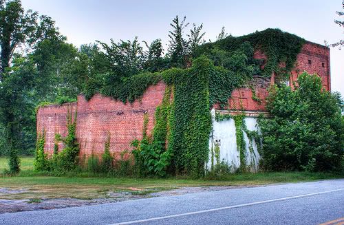
The brick plant in Van Wyck is a large production facility with multiple buildings for production and warehousing, as well as a large brick yard and piles of clay, sand and other raw materials used in the brick making process. There is a rail spur with a loading dock where box car loads of finished bricks are shipped out and a storage track across the mainline from the plant. However, to insure that I do not overcrowd the area around the Catawba River Bridge, I will model a simplified version of the brick yard along with one or two of the ancient buildings that dot the former "downtown" area of Van Wyck (Figure 4).
 

LDE: Catawba

Posted by Jamie in Lilburn, Georgia, USA Sunday, September 20, 2009 0 comments

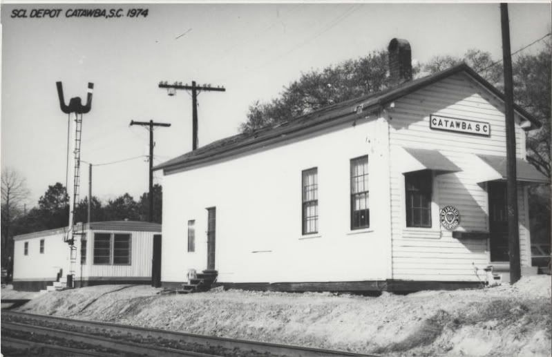
Figure 1 Catawba Depot (SCL) - 1974
Like Harmony, our previous stop on the layout tour, Catawba, SC is not so much a town as it is a rural area with a post office and a handful of residences and businesses. Catawba gets its name from the tribe of Native Americans that settled this area in the 17th century. When the Seaboard Air Line came through this area in the 1880s, they decided to name all of their stations after the Indian lands they passed through. Thus, Catawba was born. In the modern CSX era, Catawba is little more than a control point for the north end of the Catawba passing siding, although there is a trailer that serves as the "depot" for crews working the nearby Bowater Paper mill. However, in the SAL era, Catawba played a much more prominent role. First of all, there was a real depot (Figure 1), an active interchange with the Southern Railway, and the Catawba Valley Branch split from the mainline. Also, the Southern crossed the SAL on a short deck girder bridge.

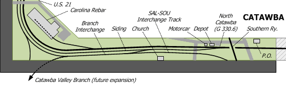
» Track Plan


» Catawba Depot

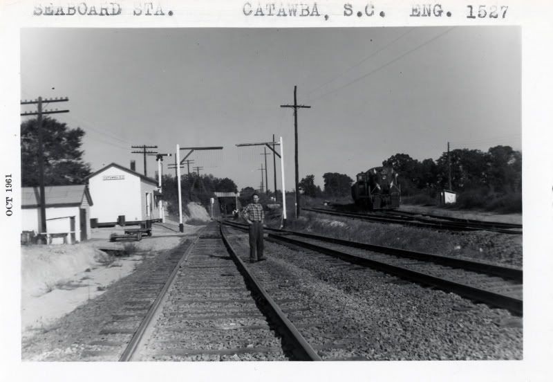
Figure 2 Catawba Depot - October 1961
The photo to the left shows just how much was going on at Catawba in the 1960s (Figure 2). To the left, you can see the depot in the distance and a motorcar shed in the foreground. The man in the photograph, presumably a Seaboard employee, is standing between the mainline to the left and the siding to the right. The siding merges with the main track just before ducking under the Southern Railway in the distance. To the right, you can see the interchange track rising up and curving away to meet the SOU mainline around the bend. The interchange track will end at the background and will be switched like a regular industry spur. There is also a house track where a local switcher was stationed, although in this photo the house track is vacant and we can see Seaboard Alco RSC-2 #1527 sitting on the interchange track awaiting its next assignment. All of the other details such as the train order semaphore signal, the pole lines and the telltales complete this classic railroad scene.

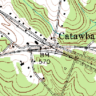
Figure 3 Catawba Depot area - 1968
The overall layout of the Catawba depot area can be observed on a USGS topographic map from 1968 (Figure 3). The Seaboard mainline (by this time the SAL had merged into the SCL) goes from west to east, while the Southern line angles down from the northwest to southeast. The interchange tracks are clearly indicated to the southwest of the crossing, although the photo from 1961 only shows a single interchange track while the map shows two. Southern had a depot at Catawba as well; it was located where the interchange tracks joined the SOU mainline. Space limitations will not allow this structure to be modeled on the layout. Also, just out of view to the right is the large yard for the nearby paper mill that was served by both railroads.

» Southern Railway

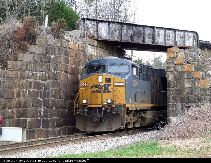
Figure 4 CSX at Catawba, SC - 2007
Brian Woodruff/RRPictureArchives.com
The Southern Railway line from Rock Hill, SC to Kingville, SC (currently the Norfolk southern SB line), crossed the SAL on a short deck bridge just north of the Catawba depot. While the bridge itself is unremarkable, the tiny opening that the SAL mainline has to squeeze through will leave you thinking there is no way a train could ever fit through. However, CSX doublestack trains pass through this tight opening daily without issue (Figure 4).

» Catawba Valley Branch

Figure 5 Catawba Valley Branch - 1968
The Catawba Valley Branch was a 22 mile branchline from Catawba to Great Falls, SC completed in 1909. The branch joined the mainline at a wye just east of the U.S. 21 overpass (Figure 5). There were two significant customers on this branchline: the Lancaster & Chester Railway, which was served via an interchange track at Fort Lawn, SC, and the Republic Cotton Mill in Great Falls. Passenger service existed at one time, but this was long gone by 1966. I plan on modeling the Catawba Valley Branch by having each leg of the wye end at the backdrop. I do plan on modeling an extended lead track to the branch that will allow through trains to exchange cars with the branch without fouling the passing siding. This will allow the branch be an active part of local switching operations, even though the actual branch is not modeled. I may also extend one of the wye tracks into the adjacent family room to allow for staging of branchline trains. The Catawaba Valley Branch was abandoned in the late 1960s and the rails were pulled up in the 1970s.

I would like to extend credit and a special thanks to Conrad Cheatham for his valuable information regarding the Catawba Valley Branch.
 

LDE: Harmony

Posted by Jamie in Lilburn, Georgia, USA Friday, September 18, 2009 0 comments

The Seaboard Abbeville Subdivision (part of today's CSX Monroe Subdivision) stretches 135 miles west to east from Abbeville, SC to Monroe, NC. Today, this line is CTC single track with passing sidings and hosts about 25 trains each day. The modeled version will adhere to this same method of operation, since the progressive SAL installed CTC on the Abbeville Sub in the early 1960s. Eastbound trains exiting the south staging yard ill enter the layout at Harmony, the westernmost visible area of the layout. This tiny burg is located in a rural area of the South Carolina Piedmont between Columbia and Charlotte, NC. While there is not much in the way of an actual town, Harmony does offer a few scenic and operational features. However, this will mostly be an isolated area that is a great place to watch trains roll through the surrounding scenery. Lots of trees to model in this area!

» Track Plan


» Harmony Defect Detector

Figure 1 Seaboard Defect Detector - Athens, GA
Nikos Kavoori/AthensRails.com
A high car detector exists on the modern day CSX at Harmony. This detector protects the Catawba River bridge to the north from cars with excessive height, even though the bridge has adequate clearance for today's modern double stack cars. When an overheight car breaks the trip wire strung at the maximum safe clearance height over the tracks, the detector is activated and an alert message is broadcast over the radio channel monitored by the train crew. The crew must then stop the train and perform a visual inspection; overheight cars are setout at the next available storage track. The cars are then repaired in place and picked up by a later through or local train.

Rather than model the bland high car detector, I will be modeling an older Seaboard-style hot box and dragging equipment detector. This style detector fits both eras nicely, as several are still in service between Atlanta and Hamlet (Figure 1). The distinctive block building is a small detail that adds considerable charm to the overall layout. I also plan on making all detectors on the layout operational (eventually) so that an audio alert message is randomly triggered every so often by passing trains. As on the prototype, the train crew will need to locate the offending car and place it in the next available setout track. This adds yet another operational wrinkle that crews must contend with.

» Harmony Team Track

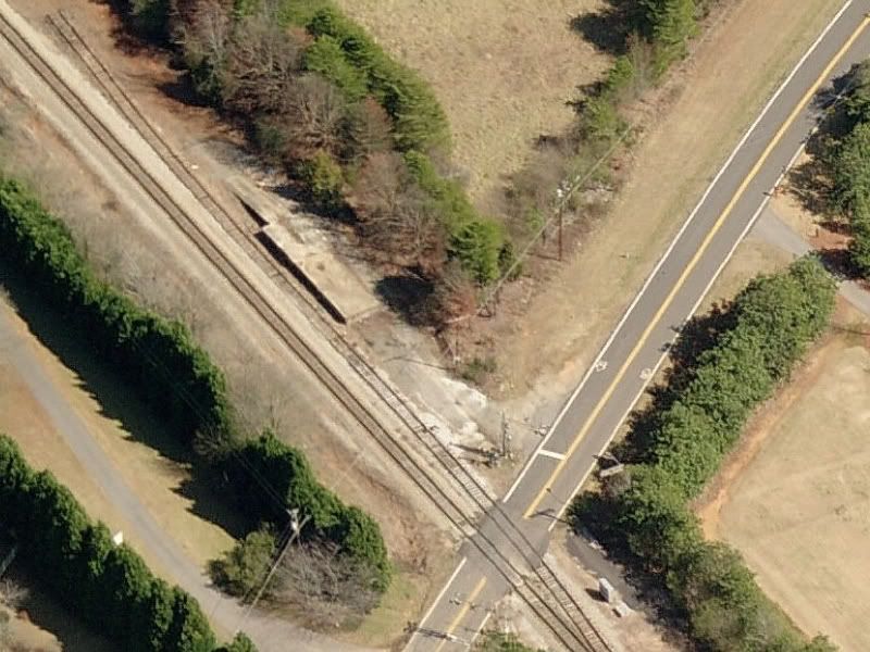
Figure 2 Team Track - Athens, GA
Harmony Road crossed the SAL mainline at grade at milepost G333.2. I decided to model a team track at this location, even though I never had any evidence indicating one ever existed in this area. A team track is a short spur track that is used for loading/unloading by railroad customers that do not have direct rail access. The term "team" originates from the days when teams of horses would lead wagons of merchandise to and from the railroad. I got the idea to model a team track when I discovered one in the middle of nowhere while railfanning near Athens, GA (Figure 2). I think the team track does a good job of preserving the "out in the sticks" feel I want for this part of the layout while still providing a local switching opportunity. A turnout, a short stretch of run down track and a simple concrete loading ramp is all it will take to create this realistic mini-scene.

I recently came across a 1948 SAL employee timetable that showed a 5-car capacity spur track at milepost G333.1, or just one-tenth of a mile from the Harmony Road grade crossing. It looks like there actually was a team track at this location after all!

» South Catawba

The SAL Abbeville Subdivision was a single track mainline with centralized traffic control (CTC) installed in the early half of the 1960s. The Catawba passing siding extended from Harmony northward to Catawba. This passing siding was (and is today) a controlled siding rather than a controlled siding.

A controlled siding has power switches and signals protecting the entrances to the siding, but the siding track is not connected to the signal system. Therefore, a train given a signal indication into the siding can only be assured that the route is cleared into the siding, but there may be equipment on the actual siding track. This is why the maximum authorized speed into a controlled siding is typically very low, usually 10 mph or restricted speed, which means the train must be able to stop in one half of the crew's range of vision.

On the other hand, the siding track in a signaled siding is bonded (connected electrically) to the signal system. This means that a train getting a clear route into the siding can be assured that the route is cleared into the siding and the siding track is not occupied by any other equipment. This allows signalled sidings to have higher speeds than controlled sidings, typically around 25-30 mph or medium speed. The speed of a siding will almost always be lower than the main track because the siding is built and maintained to lower standards, which is not a problem since trains using the siding will almost always be stopping in the siding.

Although the Catawba siding on the SAL (and still today on CSX) is a controlled siding, I will be modeling all sidings on the layout as signalled sidings. This is because I want to have block detection on all main tracks and passing tracks to support any future computerized automation I may develop. The south end of the passing siding will be protected by a set of Seaboard-style D-type mast signals.

» Neelys Creek

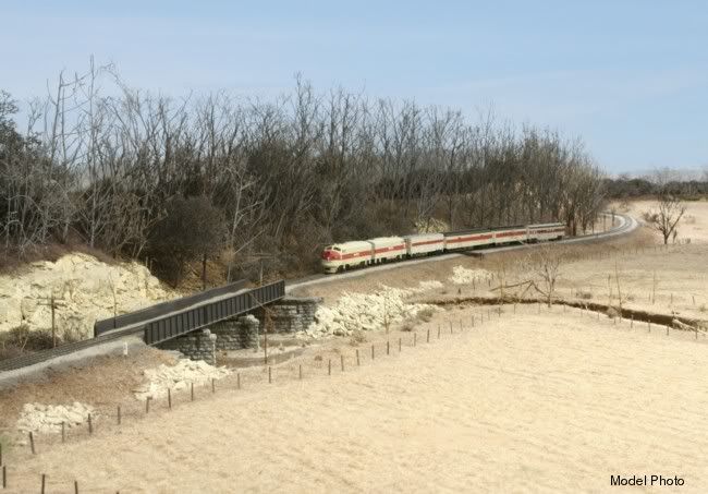
Figure 3 Lance Mindheim's N-Scale Monon
Both tracks cross Neelys Creek at Harmony. This crossing is at a location inaccessible to railfans, so I am not sure what type of crossing was/is in place during either the SAL or CSX eras. However, my vision for this part of the layout is similar to the signature scene on Lance Mindheim's N-scale Monon layout (now dismantled). The scene where the Monon crosses Clear Creek on bridge E-8 (Figure 3) is one of the most believable scenes--if not the most believable scene--I have ever seen on any model railroad. As I write this post, I am leaning towards some type of wood trestle, although I do not want the bridge to be a dominating feature by any means. The design of the Neelys Creek bridge and farm scene will most likely evolve as the layout progresses.
 

About Me

My photo
I am a professional website developer who loves to spend my free time hanging out with the family and playing with trains in the basement.

Labels